First, read Eileen's post on the new issue of postmedieval, which looks like one for the ages. And then Jeffrey's 2014 retrospective, and then this, below, which I suspect may be the final ITM post for 2014.
Or maybe not?
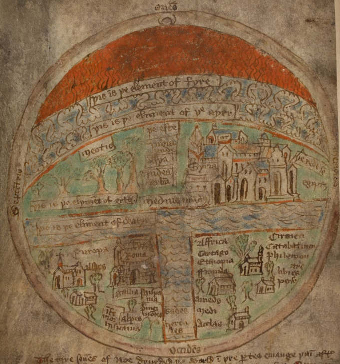
 Here's a T-O Map from the Mandeville epitome that begins that famous fifteenth-century Carthusian miscellany, British Library Add 37049, f. 2v. (also famous for including the unique copy of the Middle English "Disputation between the Body and the Worms," which I write about here).
Warning: I'm not a map scholar, and, as Chet van Duzer probably already said what I'm about to say here, I apologize. Be patient and imagine briefly that you're one of my students, befuddled, curious, and confused. Or imagine you're one of my colleagues, ideally one who knows more about paleography, maps, and medieval science than I do. I humbly submit myself to the correction of all.
I'm fond of this map because it comprises two intersecting two-dimensional planes, which together generate an approximation of three dimensions. Note, first, the geography: the left bottom quadrant is Europa, the right bottom quadrant Affrica, and the top half Asya (if I'm reading that right). Various cities and regions have been labeled: Syria, Alpes, Roma, Gallia (France), Hispania, Ethiopia, Carthago, etc.
Meanwhile, at the very top we find a band of red, which is Fire; below that, a band of clouds running through a scribble of blue, which is Air; below that, written below a band of trees, Earth; and then, dividing the Asia, Europe, and Africa, the element of Water.
If fire, being lightest, is above the slightly heavier air, and if both of these are above the surface of the earth, then the labeling of elements intersects the world map at a perpendicular. There's a catch, though: as earth is heavier than water, the labeling of elements reverses the final two, as it places water, incorrectly, below the earth. The simple explanation is that this reversal just represents our experience of our world: so long as we're not wading or drowning (or being rained upon), earth, for us, is above the water, whatever the claims of natural science.
The reversal also neatly represents our world's slightly off-kilter arrangement of elements, as explained by one far-seeing mid-fourteenth-century theorist. Jean Buridan's commentaries on Aristotle's De caelo et mundi and Meteorologica consider the question of whether the whole earth is habitable. His answer? One quarter, yes, the rest not. He doesn't get to that conclusion without some struggle. In Joel Kaye's summary, Buridan first:
raises a question that Aristotle had never considered: why would any one quarter of the earth be more likely to remain above water and habitable than any other quarter?...Given the spherical nature of the earth, given that according to Aristotelian physics all earth falls naturally to the earth's center, given the great abundance of water with respect to land, and assuming with Aristotle...that the universe is eternal...why in the fullness of time should any portion of land whatsoever remain habitable above water? (94)To save the world from drowning, Buridan concocts "an interconnected physical system in dynamic equilibrium" (95), in which heat and cold make the earth above waters slightly lighter than drowned earth, so that the earth's weight and its center of magnitude slightly differ. Only the earth below the waters is as cold as it naturally should be. The off-kilter interaction of earths of varying density, balanced in an eternal motion of unbalance, keeps exactly one ever-shifting quarter of the earth above water (96).
Is this eternal, Weeble Wobbly unbalance what's represented by the T-O map of BL Add 37049? Doubtful. More likely, it represents the lived, human experience of elements, with the earth below us, and the water, we hope, even lower. But were some Carthusian bro a committed Aristotelian (unlikely!), we can imagine him looking at this map, on the verge of unloosing yet another "well, actually," but then thinking back to his studies, and resting content, temporarily above the waters.
(for more on floods, see Jeffrey here, with "Drown").
2 comments:
Excellent post. I, too, love this odd map. What about the "waters beneath the earth" (Second Commandment)? How does that fit into the ordering of the elements? Water is both above AND below the earth, no?
I love the convolutions of this map, which attempts to but cannot quite reconcile disparate cosmic orderings. It reminds me very much of Gervase of Tilbury, who in the first book of the Otia Imperialia likewise attempts (though only textually) a cartography that will bring together different modes of apprehending the cosmos. It doesn't work but the interleaving he achieves is fantasic.
Karl, you probably know this already but the second chapter ("Machine of the World") of Robert Bartlett's The Natural and the Supernatural in the Middle Ages has much about these kinds of elemental cartographic emplotments, dealing with some of the issues you raise here.
Asa, I have a forthcoming essay on the very topic you raise: imagining the waters of the ocean as both below and above the human world. It will be out in a collection called Elemental Ecocriticism this year!
Post a Comment